Anchorage and the Mat-Su Valley have over 200 miles of trails open to mountain biking; nearly 120 miles of those have been built specifically for bikes.
Local Southcentral trail clubs Chugach Mountain Bike Riders, Singletrack Advocates and Valley Mountain Bikers and Hikers spent over a year working with national trail building nonprofit IMBA Trail Solutions to inventory, assess and identify opportunities in our regional mountain bike trail systems.
Major funding for this project came from the Mat-Su Trails and Parks Foundation, the American Rescue Plan Act (Anchorage Recovery), and private donations.
Download the full report here: ANC-MatSu MTB Plan FINAL
The Anchorage and Mat-Su Strategic Trails Plan represents a bold, community-driven effort to reimagine Southcentral Alaska’s trail systems. Spearheaded by Chugach Mountain Bike Riders (CMBR) in collaboration with local trail groups, public agencies, and regional advocates, the plan reflects more than a year of outreach, data collection, and shared visioning.
Recognizing the region’s unique combination of urban access, wild backcountry, and diverse terrain, this initiative aims to create a world-class network of sustainable, accessible, and purpose-built mountain bike trails that support both local recreation and destination tourism.
Central to the planning process was the development of two powerful tools—the Anchorage and Mat-Su Trail Attribute Tool and the Trail Analysis Tool—which together offer a detailed understanding of the character, quality, and distribution of the region’s 750+ trails. These platforms provided the foundation for a data-informed approach, allowing planners and stakeholders to assess trail difficulty, design intent, user types, and geographic gaps with greater precision. Combined with extensive input from riders, land managers, and local nonprofits, the planning team was able to identify high-impact opportunities for both new trail development and strategic improvements to existing infrastructure.
This executive summary outlines the plan’s five biggest takeaways and accompanying recommendations for improving mountain bike trail systems across Anchorage and the Mat- Su Valley. These priorities are designed to support trail accessibility, enhance ride quality, and build a cohesive,
future-ready network that reflects the values of local communities while preserving the region’s iconic landscapes.
TOP 5 TAKEAWAYS
1. Anchorage and Mat-Su Offer World- Class Diversity
The Southcentral Alaska region boasts over 200 miles of mountain bike trails, offering a full range of riding experiences—from beginner-friendly flow trails within
Anchorage’s city limits to rugged, remote backcountry routes in the Chugach Mountains and Hatcher Pass. This level of trail density places Anchorage and the Mat-Su Valley on par with established riding destinations like Bellingham, Washington and Pisgah, North Carolina. While much of the network in Alaska is still shared-use and not purpose-built for mountain
biking, the sheer volume, scenic value, and year-round access— particularly winter fat biking—make the region a standout.
With continued investment in bike-optimized infrastructure and connectivity, Southcentral Alaska is well-positioned to lead the next generation of world-class mountain bike destinations.
2. Need for Purpose-Built Trail Expansion
Many existing trails across the region, particularly in the Chugach Backcountry and older sections of Mat-Su, were not designed with mountain biking in mind. These routes often follow legacy mining roads, service tracks, or shared- use paths that lack flow, sustainability, and technical features desired by modern riders. This leads to maintenance challenges, degraded tread, and limited progression opportunities. Purpose-built trails—especially directional flow and technical lines—are essential to improving user experience and reducing conflict with other trail users. The plan identifies key areas for future construction and reroutes that would optimize trail design, including in North Bivouac, Peters Creek, the Arctic to Indian Traverse, and Hatcher Pass.
3. Urban Access and Youth Infrastructure Are Underbuilt
Despite the presence of urban parks near population centers, there is a clear shortage of bike-specific infrastructure that supports youth, beginners, and casual riders. Facilities like
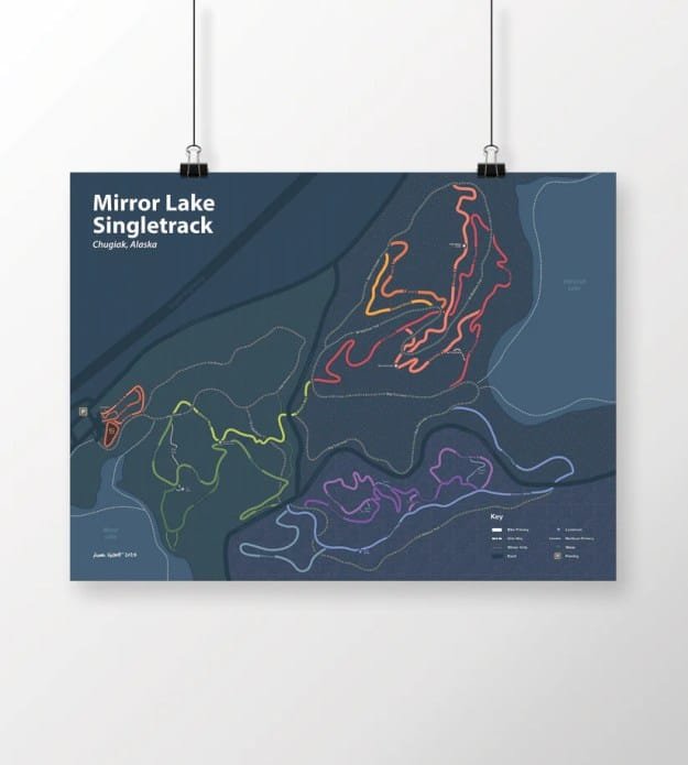
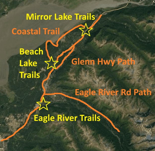
Mirror Lake, Russian Jack, and Palmer Bike Park offer good starting points but lack the breadth, durability, and visibility to fully meet community needs. New pump tracks, progressive skills areas, and short loop trails designed for families could help lower the barrier to entry for new riders while supporting skill development. These features are especially important in underserved areas of East Anchorage and Chugiak-Eagle River, where trail access is currently limited. Investing in visible,
well-designed community trail hubs will ensure mountain biking remains inclusive and accessible to the next wave of riders.
4. Trail Data Tools Enable Smart Planning
The Trail Attribute and Trail Analysis tools developed for this plan provide powerful platforms for inventorying, evaluating, and visualizing over 21,000 individual trail data points across 750+ trails in Southcentral Alaska. These tools allow land managers and advocates to identify gaps in trail difficulty, feature density, and bike optimized trail types—enabling more strategic and equitable investment. By filtering and comparing trail systems, planners can also measure network strengths, highlight underutilization, and better understand where trail upgrades or expansion are most needed. The tools support public engagement by making trail data more accessible and actionable. With continued updates and use, these resources will be central to ongoing planning, maintenance, and grant application processes.
5. Backcountry and Connectivity Gaps Remain
While Anchorage’s urban trail systems are relatively well- connected, there are still significant gaps in trail access across the broader region—particularly for backcountry routes and underserved neighborhoods. High-potential corridors like the Arctic to Indian Traverse and Upper Winner Creek remain underdeveloped, with limited signage, rough tread, and barriers to looped or point-to-point riding. In the Mat-Su,
efforts to connect zones like Hatcher Pass to Government Peak are still in early stages, and fragmented land ownership poses
logistical challenges. Within urban areas, neighborhoods in East Anchorage and Chugiak-Eagle River lack clear, safe connections to nearby trailheads, limiting access for those without vehicles or nearby options.
Trail data and population density maps offer valuable tools for identifying where new connections will have the greatest impact. By overlaying demographic and access data, planners can prioritize trail segments that fill connectivity gaps, especially in high-need areas. Expanding connector trails, improving signage, and developing sustainable backcountry routes will be key to creating a more cohesive, inclusive trail network across Southcentral Alaska.