Please go to Recreational Trails Plan – PublicInput and give a thumbs up on our proposed Chugiak-Eagle River trail projects. Feel free to add your own comments as well.

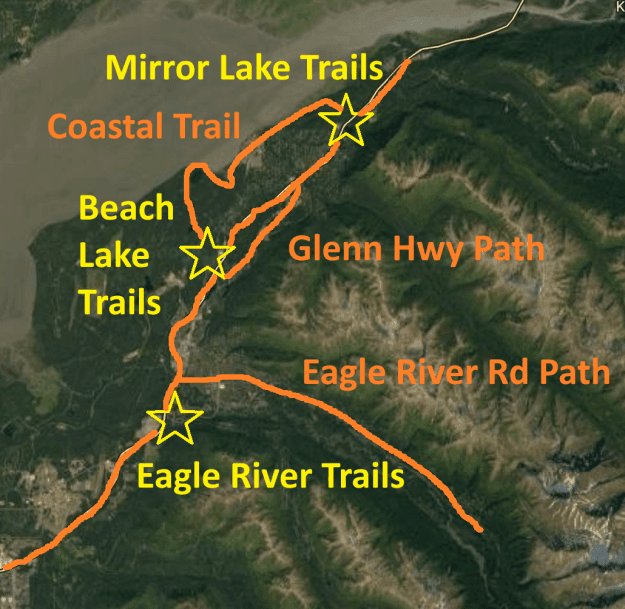
While the proposed update to the Recreational Trails plan includes two high-priority trails: the Lower Eagle River Trail from Briggs Bridge and the Northern Extension Coastal Trail from Beach Lake Park to Mirror Lake Park, we are concerned that dozens of planned trails have been cut.

The basic plan for Chugiak-Eagle River’s Recreational Trails has been the same for 40 years. This is a great plan. Let’s keep it.


DRAFT COMMENTS:
- Please include the Iditarod National Historic Trail (INHT) through Chugiak-Eagle River, and the recent efforts of Chugiak-Eagle River Parks and Recreation Department to reestablish this trail in our community. The INHT comprehensive plan calls for a “parallel recreational trail” that follows the general path of the historic trail. Starting at the Eagle River Nature Center, the INHT runs along Eagle River Rd, cuts through downtown Eagle River, and connects with the proposed Coastal Trail. The New Beach Lake Multiuse Trail has been officially designated as a part of the INHT.
- Include Creekside Trail easments along Fire Creek, Peters Creek and Mirror Creek that the Municipality retained though the ANILCA. Also incldue the new Public Use Easement that follows Edmonds Creek.
- Include all areawide trails for analysis and planning. This includes, but is not limited to AMATS recreational trails, AMATS nonmotorized pathways, adjacent Chugach State Park trails, and major trail easements (such as Fire Creek, Mirror Creek and Peters Creek). While this plan makes recommendations for recreational trails within the AMATS boundary, it is necessary to map and list adjacent trails and nonmotorized pathways to create a clear and comprehensive plan.
- Inventory trails from 1997 Areawide Plan and match to trails in new plans including Chugach State Park (CSP) Trails Plan, ands the AMATS Nonmotorized Plan (NMP). If 1997 trails are not included in the CSP Trails Plan or NMP, they must be included or updated in this Recreational Trails Plan, as recommended by the 1997 plan. The splitting of a single trails plan into three separate parts has made overall planning efforts difficult. This Recrecational Trails plan needs to capture any trails missing from the updated documents.
- Specific trails must be mentioned and mapped in the new plan. Consistent with NMP, CSP Trails Plan and the 1997 Areawide Trails Plan, existing, planned, and proposed trails must be listed and included on the recreational trails plan map, not just general guidelines for trails.
Chugiak-Eagle River Trails needed on Recreational Trails Plan Map per previous plans and community requests:
a. Add the Iditarod National Historic Trail “parallel Recreation Trail” along Eagle River Rd, Beach Lake Trail and the Northern Extension Coastal Trail.
b. Glenn Hwy Pathway – complete gaps at VFW Rd, Artillery Rd Exit, and Mirror Lake to the Native Village of Eklutna. (several gaps are missing from NMP)
c. Eagle River Rd Pathway – complete to Nature Center (several sections missing from NMP)
d. Old Glenn Pathway – this is completed to Peters Creek (NMP is incorrect)
e. Eagle River Loop Rd – separated pathway, not just wide shoulder (per 1997, missing in NMP)
f. Fire Creek, Mirror Creek, Peters Creek, Edmonds Creek connections from Coastal Trail to Glenn/Old Glenn Pathway (per ANILCA land Agreement, Northern Extension Coastal Trail Plan, 1997 Areawide Trails Plan, Mirror Lake Plan, Beach Lake Master Plan)
g. Beach Lake Trail (per Beach Lake Master Plan, connects Glenn Path to Coastal Trail)
h. MacDonald Center to Mt Baldy Connection via Carol Creek (in housing development plat via HLB lands)
i. Reroute Coastal Trail away from Native Village of Eklutna (per planning overlay district) – Use new Edmonds Creek public use easement instead.
j. Add Mount Baldy Trail Access. This is open and secured on Muni Parkland.
k. Lower Eagle River Trail (Eagle River Greenbelt from Briggs) – Fix Trail Name
l. Ram Valley – Legal access is needed.